⛅ Tower Hill weather, loading...

The farm

Catching every drop: the swales that came first

Our own farm design and water works at Tower Hill. We finished the design and dug the swales before the carbon project began.

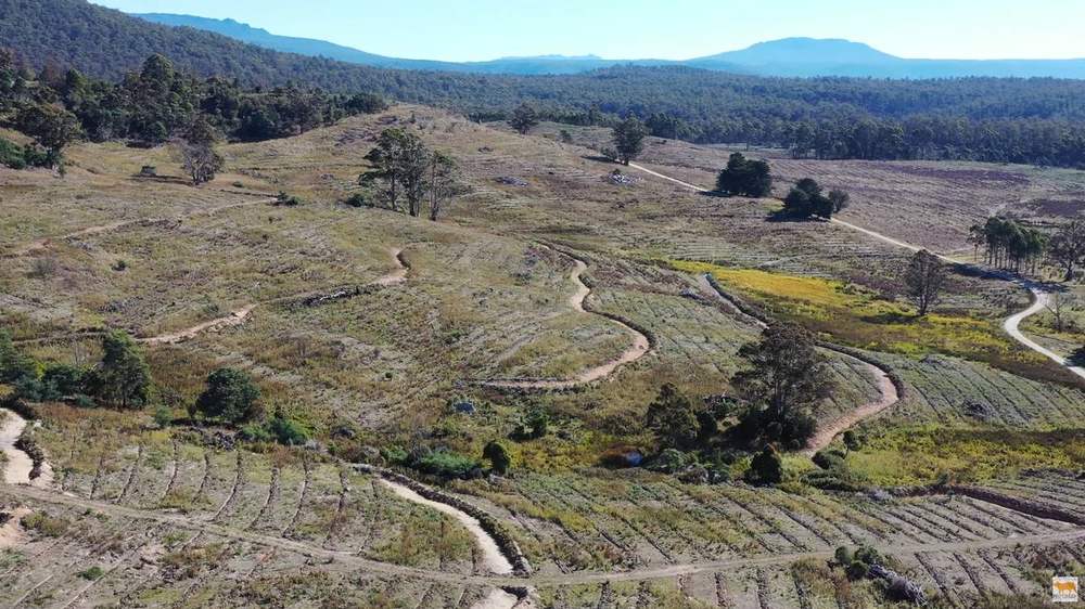
Our swales following the contours across the hillside, from the drone. 3 Sep 2023.

The swales came first, as our own farm water works, and the trees for the carbon project went in later. Read about the trees we've planted, and how the animals will graze under them one day.

Designing with permaculture

Our farm is laid out using permaculture design, the approach taught by Geoff Lawton (opens in a new tab), one of the best known permaculture teachers in the world.

Drone view of a paddock with rows of regrowth and forest beyond

The idea is to work with the land instead of fighting it. Before we dig a hole or plant a tree, we read the landscape: where the water runs, where the frost settles, which way the wind comes from and where the sun hits. Then we design around it, so the water, trees, pasture and animals all have a job, and each one helps the next.

A hillside of the farm with scattered trees and ripped lines, seen during a permaculture design session
Out on the hillside during one of our design sessions. May 2023.

Our design sessions with Geoff Lawton

Tower Hill Permaculture Project - Planning Session 01 with Geoff Lawton & William
Geoff Lawton Permaculture planning session 2
Geoff Lawton Permaculture planning session #3 - Part 1
Geoff Lawton Permaculture planning session #3 - Part 2
Geoff Lawton Permaculture design session 4

Short clips

After the 2019 drought and bushfire, we're drought proofing the farm with swales. With Geoff Lawton.
About 80,000 native trees and shrubs planted in our carbon project across about half the farm, and we're planting about 20,000 more for the bees and fodder that aren't part of the carbon project. The carbon planting is on a 6 x 6 metre grid, with the trees planted a little closer along the rows to allow for losses, with pasture underneath. With Geoff Lawton.
We chose low trees so that, once they're established, livestock will be able to graze among the tea tree. With Geoff Lawton.
Geoff Lawton reads the lidar maps that show where the land picks up moisture. With Geoff Lawton.

Why we built the swales

Drone view of swales on contour across the hillside

North East Tasmania can get very dry. We can go weeks, sometimes months, without decent rain, and the ground bakes hard. Then a big rain event rolls through and most of that water runs straight off the farm, down the gullies and away, taking good topsoil with it.

Cross-section of a swale dug on contour, with a planted mound and water soaking into the ground
Illustration

Swale works

Freshly dug swale and mound running across a hill paddock, with forested hills behind
Excavator digging swales on a hillside, with cattle grazing beyond
A long swale curving across the paddocks below a cloudy sky
Freshly dug swale and mound along a paddock at sunset
New swale and mound with a little water in the bottom, below a line of forest
Swale holding water as it curves along the paddock edge below tall trees
Swale holding water after rain, with a fresh mound beside it
Swale filled with muddy water after rain, with gum trees beyond
Swale holding a strip of water across a freshly worked paddock
Swale holding water below a fresh mound with young plants
An excavator digging a swale on a misty hillside
An excavator building a swale mound
An excavator piling soil for a swale mound, with paddocks and ranges beyond

We wanted to turn that around. The plan is simple: catch as much water as we can, slow it down, spread it across the landscape and let it soak into the soil.

So what's a swale?

Drone view of swales slowing water so it soaks in

A swale is a level ditch dug along the contour of the land, with a mound of soil on the downhill side. Because the ditch is dead level, water that runs into it doesn't rush off one end. It sits there, spreads out along the whole length and slowly sinks into the ground.

The mound below it is a great spot for trees, because their roots end up sitting right where the moisture goes.
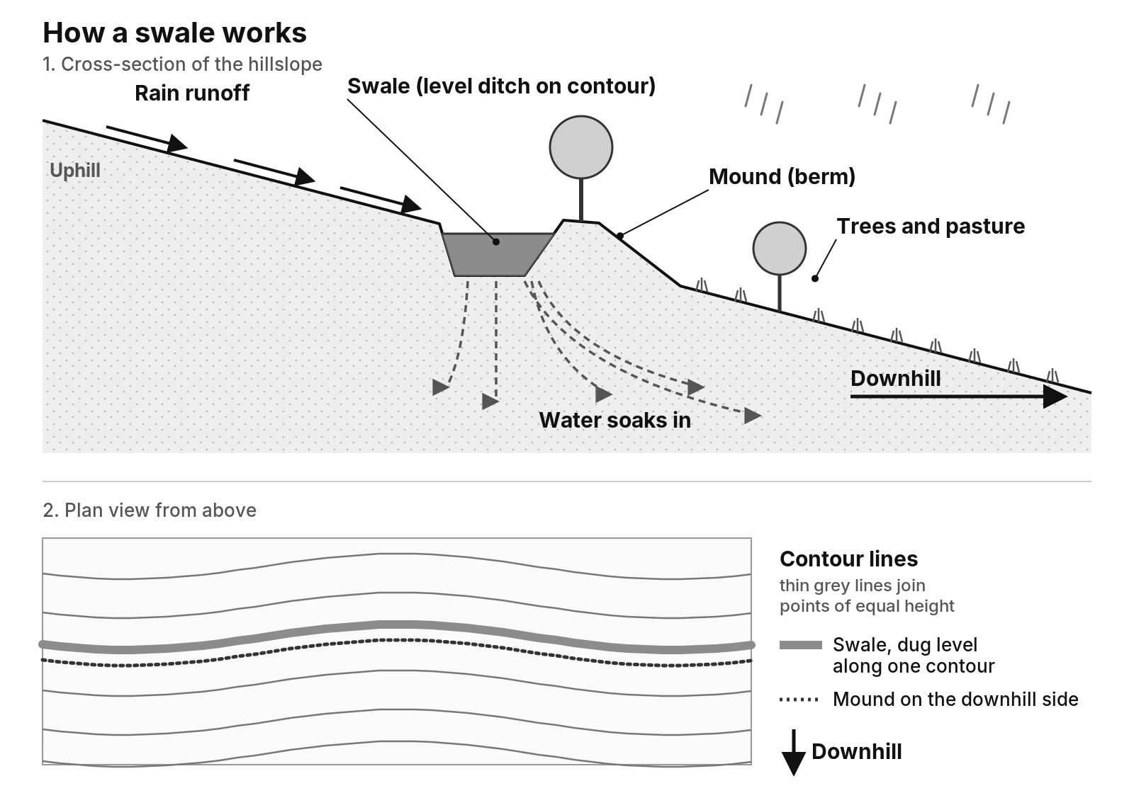
Diagram of a swale. In a cross-section of a hillslope, rain runoff flows downhill into a level ditch dug along the contour, with a mound of soil on the downhill side. The water pools in the ditch and soaks into the soil, spreading under the mound to trees and pasture below. A plan view shows the swale following one contour line, with the mound just downhill.
How a swale works. Tap to open full size.

What the swales do for the farm

  • Recharge the groundwater. Water that soaks in fills the soil and the ground below, instead of running off in a rush.
  • Subsoil irrigation. The water held in the soil below each swale keeps feeding the grass and tree roots for weeks after the rain, with no bores or pumps.
  • Less erosion. Slower water means our topsoil stays on the farm.
  • Springs and creeks that run longer. That's the aim, anyway. Water that soaks into the landscape seeps out slowly downhill, so it can help springs and creeks keep running further into the dry season. That helps more than just us: the swales on Fonthill Farm, for example, can help keep water flowing into the creeks that run down to Mathinna and on into the South Esk River.

The proof is in the rain

The Fingal Valley is one of Tasmania's driest districts, sitting in the rain shadow of Ben Lomond (see the Bureau of Meteorology records for Fingal (opens in a new tab)), so a big fall like this is worth a lot.

On 14 December 2023 we got 93.8 mm of rain overnight. First thing the next morning we went out to check the swales, and most of them had a lot of water in them. Only a few that we hadn't yet joined up with culvert pipes were light on. Instead of that rain running off the slopes and off the property, we had a chance to soak a good share of it into the soil to carry the ground through summer. We even noticed a few springs popping up downhill. So very pleased!

Rainwater lying along the length of a freshly dug swale between grassy banks
After 93.8 mm of rain overnight, water sitting in the swale. 14 Dec 2023.
A long swale channel full of brown rainwater running along the contour
The swale channel holding water the morning after. 14 Dec 2023.
Water held in a swale with a mound of soil on the downhill side
Water held along the swale the morning after. 14 Dec 2023.

Watch the swales at work

From above

In August 2026 the Google satellite images updated over most of the farm, and you can now clearly see the on-contour swales we've dug across the landscape to slow, spread and soak every drop. There's lots more to do over the next few years, starting with more ponds and dams.

Satellite view of the farm with curving on-contour swale lines across bush and cleared paddocks
The on-contour swales showing up on the satellite view. Aug 2026. Imagery: Google

And when the rain comes back, so does the water. In June 2026 the swales and ponds were refilling to help rehydrate the farm, on a damp afternoon when we were also moving straw for the pigs' bedding.

A small dam full of water beside a round straw bale, planted rows in front and misty pines behind
Swales and ponds refilling on a damp afternoon. 16 Jun 2026.

How the swales came together

Drone view of how the swales came together
  1. 25 Feb 2023: Mapping starts on the Tower Hill Project.
  2. 16 Jun 2023: The swale works begin. William's office view for a while: the excavator seat.
  3. 17 Jun 2023: Day 2, and the first swale is finished. It's the highest one on the property.
  4. 22 Jun 2023: Our 2nd 500+ metre swale is nearly done, and we decide to extend it by another 100 m to catch more hill run off.
  5. 14 Dec 2023: 93.8 mm of rain overnight, and most of the swales are full the next morning.

Between June and September 2023, it took us just over 3 months to build our swales. We now have about 10 km of swales in, with about 5 km more planned as future works.

Building them

A long, freshly excavated swale trench running across a cleared hillside
Our 2nd 500+ metre permaculture swale, mostly completed. 22 Jun 2023.
Bare earthworks with a dug trench and spoil along a contour line
Earthworks along the contour. 22 Jun 2023.
A level sill spillway at the end of a swale, with spoil mounds beside it
The level sill spillway, roughed in and ready for raking. 22 Jun 2023.
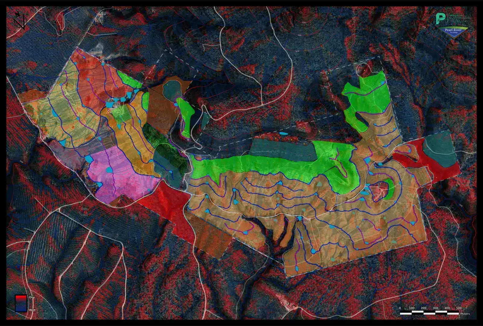
The wet and dry map from our Geoff Lawton permaculture design, showing where water gathers and where the ground dries out. May 2023.
The wet and dry map from our Geoff Lawton permaculture design, showing where water gathers and where the ground dries out. May 2023. Tap to open full size. Map: our Geoff Lawton permaculture design.
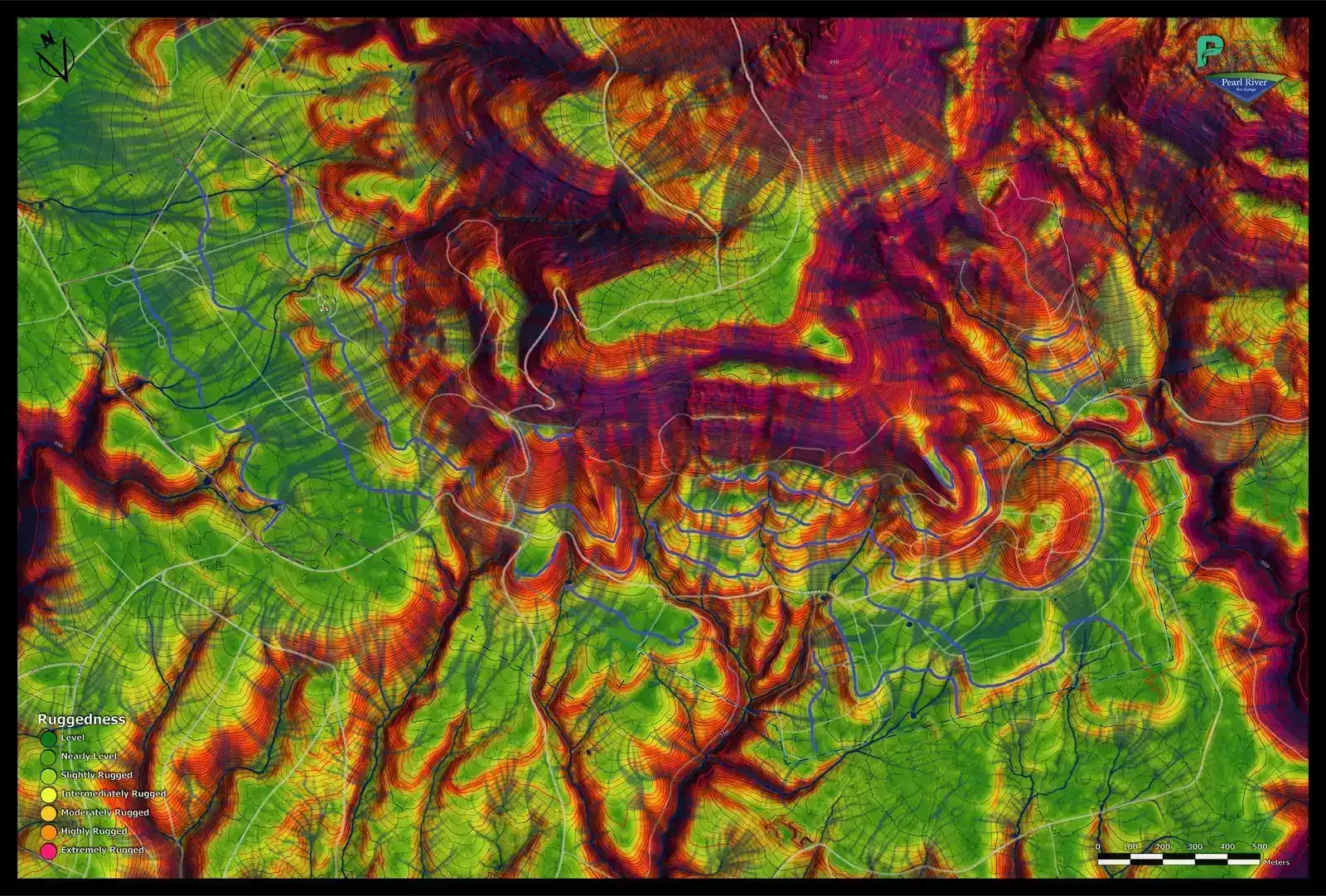
Draft swale locations over the ruggedness map. May 2023.
Draft swale layout. May 2023. Tap to open full size.
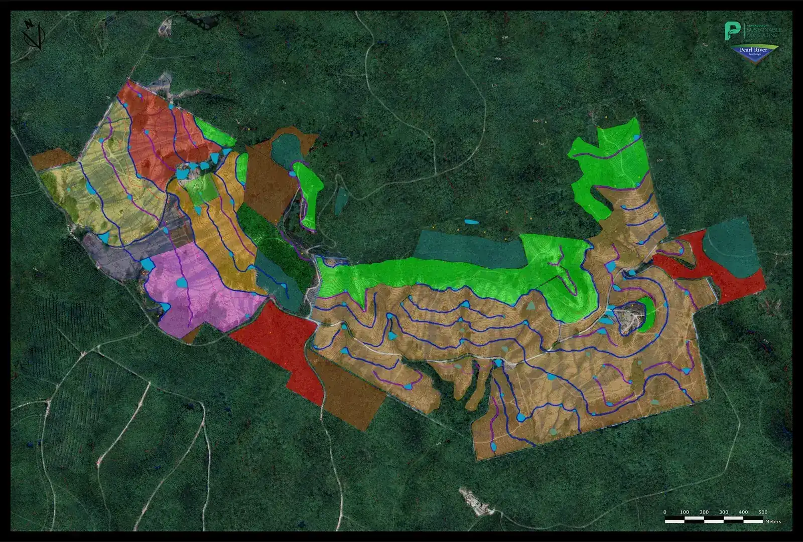
Design map of the farm over satellite imagery with the tree cover marked
Tree cover. May 2023. Tap to open full size.
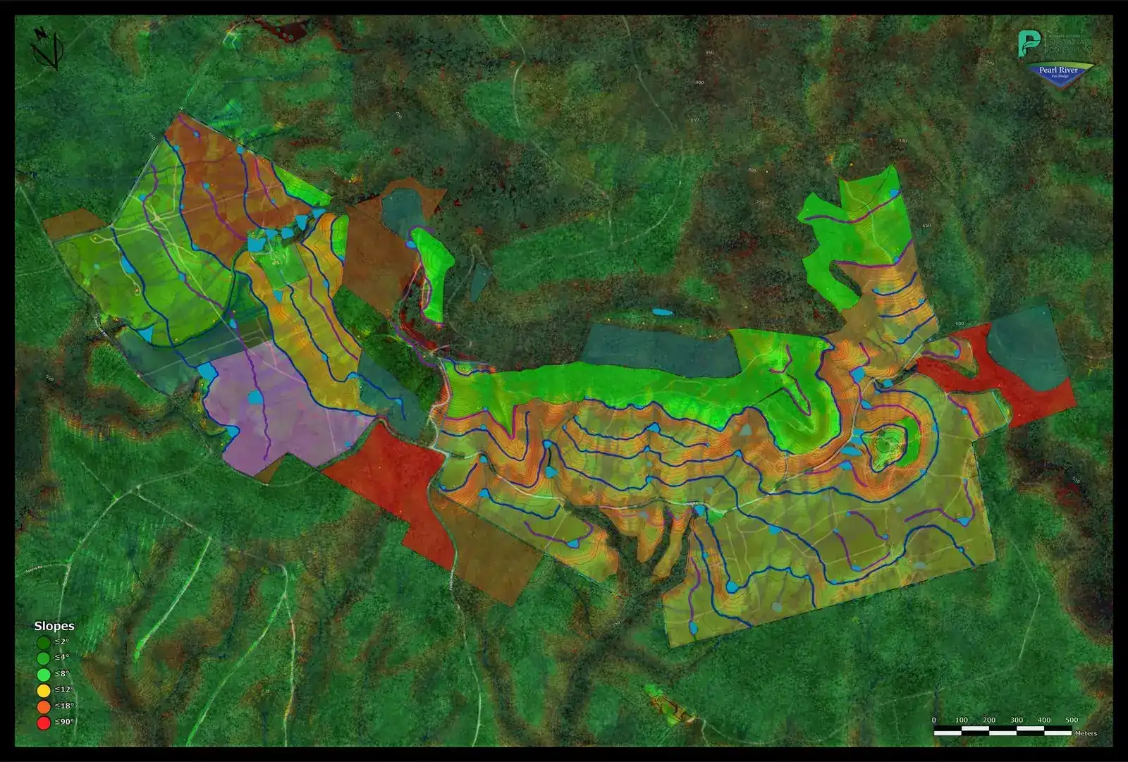
Design map of the farm shading the steepness of the slopes, with tree cover marked
Slope and tree cover. May 2023. Tap to open full size.
Drone view of swale lines snaking across a hillside paddock
The swale lines from above. 8 Sep 2025.
Drone view across swale lines on the farm with forest and distant hills
Looking out over the swales towards the hills. 8 Sep 2025.

Getting the ground ready

Our permaculture design was finished and our swales were dug between June and September 2023 as part of our own farm water works, before any rip lines were cut or trees were planted for the carbon project. The planting rows were ripped on contour after that. Together they help the farm slow, hold and spread a lot more rainwater, right where the young trees need it.

A hillside with lines dug along the contour, scattered trees and a forest edge behind
Our swale works in progress on contour, part of our own farm water works, before the carbon planting began. 3 Aug 2023.
A swale running across a paddock with rows of young planted trees and bush behind
A swale line across the paddock, with young planted trees in the rows nearby. 14 Dec 2023.

Today, and where we're heading

Drone view of our swales following the contours across the hillside
Our swales from the drone today.
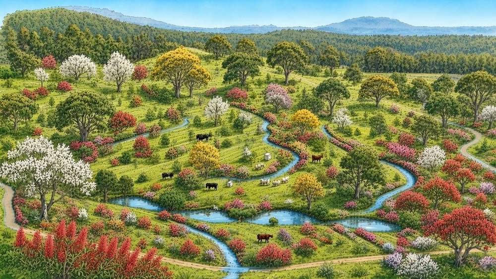
Artist's impression: the same hillside after 10 years of tree growth along the swales
Artist's impression of the farm after 10 years of growth

Tap either picture to open it larger.

Future plans

Aerial view of a small farm dam with a crescent-shaped wall in a grassy paddock
One of our dams from the drone. Mar 2023.

Our big goal is to drought proof the farm. We're not there yet, but every bit of water we catch and every tree we plant gets us a step closer. Next on the list:

Cattle grazing with the mountains behind
  • Extend the swale and drain design across more of the farm.
  • More ponds, dams and leaky weirs, subject to approvals. See our future projects.

A leaky weir is a low, porous barrier across a creek, often made of logs, branches or rock. Water still gets through, but it slows the creek flow right down, so more of it soaks into the banks and the ground around it instead of rushing away.
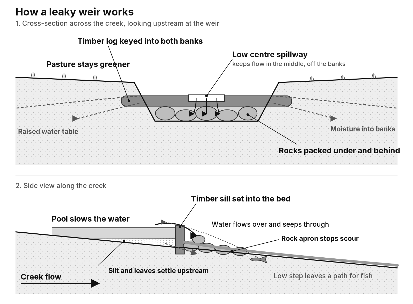
How a leaky weir works: stone and timber weir cross-section and side view
We're planning stepped ponds with stone and timber leaky weirs along Pig Creek, subject to approvals.
Drone view of trees planted on the swale mounds